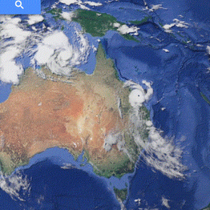
Queensland threatened by a "cyclone sandwich".

Warrigal

SF VIP
Two cyclones are headed for Queensland from opposite directions.

Wild weather to hit Queensland and Northern Territory as Cyclone Marcia and Cyclone Lam approach

FIERCE winds have torn trees out by their roots and hundreds of families have fled their homes as a “cyclone sandwich” approaches the north of Australia.

WHAT WE KNOW:


* Cyclone Lam near the Northern Territory is category 3 and Cyclone Marcia off the Queensland coast has strengthened into a category 4 cyclone.

* Severe Tropical Cyclone Marcia is due to cross the Queensland coast between Mackay and Gladstone early on Friday morning with destructive winds with gusts of up to 270 km/h expected near the core of the system. (BoM)

* As forecast, Tropical Cyclone Lam has made a southwest turn towards land, and is expected to cross the coast near Elcho Island overnight as a high Category 3, or Category 4 system. (BoM).

7.32pm Elcho Island update:
Power is out on the Northern Territory island. Residents will potentially see destructive winds for another 6-12 hours as the eyewall passes closes to communities. The @BOM_NT’s Ben Suter says Elcho Island is seeing gusts up to 130km/h and could increase up to 230km/h

7.20pm #TCMarcia’s new arrival time: 6am tomorrow, north of Yeppoon. via @JessMillward9/@9NewsBrisbane.

7.15pm
Sky News Australia reports will present very destructive winds above 200km/h over Wessel Island and will extend along the coast between Milingimbi and Gapuwiyak.

6.49pm The time to take shelter is now.

Queensland Premier Annastacia Palaszczuk and the Bureau of Meteorology have warned Marcia’s wind gusts could reach 270km/h when it makes landfall.
 

Hmmm, not sure if our blizzards are worse than your cyclones...
 

Weather patterns are shifting, and becoming more severe, all over the globe. The scientists blame it on Global Warming, and the Deniers say it is just part of the trends that have taken place on this planet forever. Whatever the cause, it will probably only continue to get worse...and humans better start looking at how to prepare for it.
 
It's 7 am in Queensland now. Cyclone Marcia is expected to hit in 2-3 hours just north of Rockhampton as Cat 5 and will track down the coast to the border with NSW. High tide will be happening around about 10am so the coastal areas will experience storm surges which could be as much as 2.6 metres. Cyclone Lam, Cat 4 is currently tracking across Arnhem Land in the Northern Territory which is much less densely populated as the Queensland coast.

Evacuations have taken place in both areas. Power outages are expected for up to two days.
 
I'm perfectly safe thanks Jim because I live in temperate Sydney. We should get some rain out of this but Brisbane and SE Queensland is expecting flooding. Further north there will be storm damage and more severe flooding. If cyclone Marcia were to track inland it would weaken and bring needed rain to some very dry areas but it is expected to track south along the coast before spinning off towards New Zealand.

This system has gone from category 1/2 to category 5 very quickly due to the high temperature of the ocean off N Queensland (did someone mention global warming?) It is also picking up speed as it gets closer.

I have relatives living in SE Queensland and they are filling their bath tubs with water in case of power outages.

The other cyclone over the Northern Territory has crossed the coast east of Darwin and is tracking inland and weakening as it goes. Remote Aboriginee communities are most at risk and there have been evacuations using small planes and helicopters. Roads are already impassable due to the Wet and airstrips are rather rudimentary in the Top End.

You've got to feel sorry for the Queensland Premier. She's only been in the job for a week and has a major emergency situation looming.
 
Cyclone Marcia has reached the coast and everything in Yeppoon is in lockdown but some idiots are still out in their cars. The fruit bats are on the wing. I don't know if they will be able to just ride out the storm in the air.

yepoon.GIF
 
I guess if RockHamton in in its path, the Grand Duke is also. He's sitting, I think, just north of Bandabung. Looks like Darwin is hit from the other one.
 
Rockhaven and Bandabung? Love it! :lofl:

Grandduke is copping a lot of rain ATM and a snake has tried to find shelter inside his house.
Other than that he is OK. Some local roads are flooded already but he can still get out for supplies.

Cyclone Lam crossed the coast east of Darwin and is travelling south.
It is losing steam as it travels inland.
 
We do emergencies like this one, where there is plenty of notice, very well.
No-one needs to die because there are evacuation centres and most of the newer buildings in the tropics are built to cyclone standards.
 

Back
Top