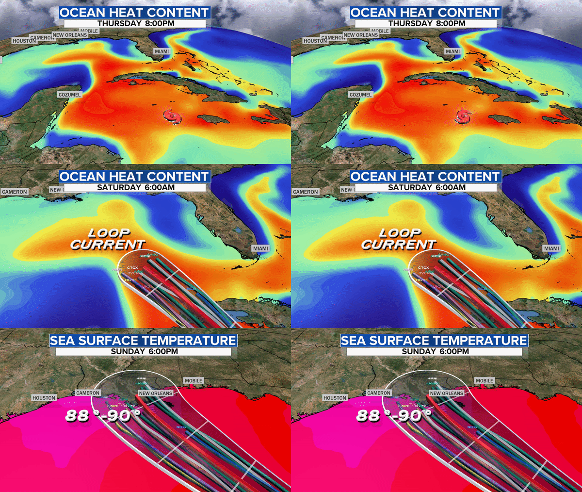
Hurricane Ida

Anyone in south Louisiana? My 95 year old aunt lives in Houma, could not be in a much worse place if the storm follows its currently projected path. My cousins evacuated her to Baton Rouge yesterday.

This is forecast to be a category 4 storm, and if it follows this path it has the potential to put more storm surge into New Orleans than Katrina did... Hopefully it does not strength so much.
 

This one could definitely be huge. :(

The Gulf water is warm, now, and those predicted landfall areas are so low and vulnerable. There also is not much time left, for this storm to make any major unexpected changes in course.:confused:

I hope that people who wanted to get to another location, have managed to do so.
 

Last edited:
This hurricane is shaping up to be very strong....perhaps as bad as Katrina or Harvey from a few years ago. Those hurricanes killed over 3,000, left thousands homeless, and caused over 200 billion in damages.

Even if this one isn't among the worst in intensity, the damages will likely be extreme, and those injured will have few options for medical care, as the Louisiana hospitals are already full of Covid patients.

Our State emergency teams are already geared up to head that way as soon as the storm passes, and they are filling trucks with tents and medical gear.
 
They have hospitals full of Covid patients in N.O., and they don't plan on moving anyone from those locations.

The hospital situation was horrible in NOLA post Katrina. After many days at searing temperatures, flooded lower floors and no hope of evacuation, one doctor (reviewed and not charged due to the circumstances) euthanized several critical care patients that were too ill to move before landfall. Cannot begin to imagine how much worse it's going to be in the middle of the Covid surge.
 
Last edited:
The hospital situation was horrible in NOLA post Katrina. After many days at searing temperatures and no hope of evacuation, one doctor (reviewed and not charged due to the circumstances) euthanized several critically ill patients that were too ill to move before landfall. Cannot begin to imagine how much worse it's going to be in the middle of the Covid surge.

I know @AnnieA ... each new update coming out seems to get more dire.

The Gulf waters are hot
ida-ohc-sst.gif
 
perhaps as bad as Katrina or Harvey from a few years ago
It has the potential to be worse. Katrina passed to the east of NO, the "good" side. The northeast quadrant of a hurricane is always the worst, stronger winds and more storm surge, in Katrina this all passed east of New Orleans, the result was a ~8 ft storm surge in NO, and ~24 ft to the east in Mississippi. If the storm had tracked 50 or 100 miles to the west things would have been much worse in NO. Ida is currently forecast to follow that more westerly track exactly.

Harvey first struck much farther west in Texas. The tremendous flooding damage it weakened to a tropical storm and slowly drifted eastward. The flooding was mostly from heavy prolonged rain, not storm surge. That's not likely to happen this time, but the storm surge risk is real and significant.

Betsey in 1965 was the last big one, in the NO area, before Katrina. It followed the most westerly track, similar to what is forecast for Ida. It did a lot of damage in NO, however it did not cause as much damage as Katrina. I am not quite sure why, but I do know that in 1965 Louisiana has a lot more coastal marshes and wetlands to protect it. An awful lot of that's gone today. My aunt and uncle and cousins were in Houma for Betsey, the eye passed right over them. Their house survived, the same house my aunt still lives in today. Hope she is so lucky again.
The hospital situation was horrible in NOLA post Katrina. After many days at searing temperatures, flooded lower floors and no hope of evacuation, one doctor (reviewed and not charged due to the circumstances) euthanized several critical care patients that were too ill to move before landfall.
I have a cousin who was a nurse in one of those hospitals. She was lucky not to be in town when it happened. Her description of conditions at Charity Hospital were almost unbelievable. As you say flooded lower floors, no power, no water, no working toilets, stifling heat and stench.... The doctor you mentioned could have left at any time but he stayed to endure those conditions to do what he could for the patients, incredible that he was even investigated. Evacuation of the healthy was not the problem...
 
I've just been viewing the coverage on the Weather Channel. The roads heading out of New Orleans are jammed with slow moving traffic, heading both East and West. There are 2 immediate problems....1, running out of gas, 2. finding a place to stop and go to the bathroom. Thousands of vehicles are slowly making their way to Texas and Alabama, and probably North into Arkansas.
 
Now hearing if it stays on track and strengthens even a little more than predicted (which often happens over the Gulf), that it'll still be Cat 2 when it comes over us. On this track, the eye will pass close to us. Please pray for us ...Covid has our hospitals beyond capacity already.

Another concern ....not to the human extent, but still very sad for a farmer's daughter is that a great deal of soybeans and cotton in the fields will be destroyed throughout the inland path encompassing several states.
 
The Weather Channel is saying it will be a Cat 3 storm...winds up to 130MPH as it reaches shore....with storm surges as high as 9 feet....with a couple of areas seeing as much as 15 ft. Power outages, that may continue for weeks, is also being emphasized. Rainfall totals could almost be record setting near the shoreline.
 
Last edited:
They have hospitals full of Covid patients in N.O., and they don't plan on moving anyone from those locations.
Excellent point, yet more deaths will result by those too "smart" to get vaccinated. They should be moved to roof tops so the injured can come in from the storm with their injuries.

The storm is now slowing to a crawl meaning a long duration wherever it lands. Those on interstate I10 hopefully will not experience the nightmare in Houston when the population tried to escape on north bound I45 years back.

People in Louisiana have not yet been paid by SEMA and some have not yet repaired their homes from last year's hurricane Laura
 
The storm is now slowing to a crawl meaning a long duration wherever it lands. Those on interstate I10 hopefully will not experience the nightmare in Houston when the population tried to escape on north bound I45 years back.

Was thinking about that this morning! .... Our family stayed put during that evacuation nightmare, but I remember all the people running out of gas on the highways, and some dying trying to get out.
 
Now hearing if it stays on track and strengthens even a little more than predicted (which often happens over the Gulf), that it'll still be Cat 2 when it comes over us. On this track, the eye will pass close to us. Please pray for us ...Covid has our hospitals beyond capacity already.

Another concern ....not to the human extent, but still very sad for a farmer's daughter is that a great deal of soybeans and cotton in the fields will be destroyed throughout the inland path encompassing several states.

Thinking of you Annie .... it is supposed to jog east as it goes inland over Mississippi. Stay safe.

We are also getting a loud thunder/lightning storm show this afternoon in NW Houston.
On the radar map it looks like an outer band from the approaching storm to La.
 
Thinking of you Annie .... it is supposed to jog east as it goes inland over Mississippi. Stay safe.

We are also getting a loud thunder/lightning storm show this afternoon in NW Houston.
On the radar map it looks like an outer band from the approaching storm to La.
I saw on the Weather Channel there is a something in the eye that is joggling and as you say is bending its slightly to the east. It just started raining here in the Champion Forest area. No thunder.
 
The Weather Channel is saying it will be a Cat 3 storm...winds up to 130MPH as it reaches shore....with storm surges as high as 9 feet....with a couple of areas seeing as much as 15 ft. Power outages, that may continue for weeks, is also being emphasized. Rainfall totals could almost be record setting near the shoreline.
Yes, I see the National Hurricane Center has lowered its forecast of peak winds at landfall a little too. A bit of good news, its still a dangerous storm though, we'll have to see what happens tomorrow.

Landfall and peak wind forecasts are better than storm surge forecasts. I hope the current one of no more than about 8 feet at New Orleans is right. If it is the levees should hold, of course they "should" have in Katrina. The forecast is higher further west, up to 15 feet between the River and Morgan City, if it happens that will be devastating to some. My aunt's home in Houma is right in the middle of that higher water level forecast. Not sure what the elevation of her home is, but little in Houma is above 15 feet. https://www.nhc.noaa.gov/refresh/graphics_at4+shtml/154856.shtml?peakSurge#contents I hope they are wrong on this one...
 

Back
Top