RadishRose
SF VIP
- Location
- Connecticut, USA
Looking at flooding in Ft. Meyers now...... oh my gosh, it's awful! Parked cars are starting to float.
If Jim Cantore really is in the eye wall its not real strong, no where near 150 mph. Jim Cantore is not to be trusted, he will do anything to try and sensationalize hurricanes, he has been caught staging shots by doing things like filming in the back of a speeding pickup truck to simulate wind.Live on the lee side of an upper story hotel on the eyewall:
https://weather.com/storms/hurrican...t-landfall-florida-damaging-winds-storm-surge
Yep hurricanes spawn tornadoes, sometimes that is how the worst of the damage is done.Small planes destroyed by tornadoes.
it syas it's currently pummeling the SW of Florida.. for the unitiated can you or someone tell us what towns or cities are in SW Florida.. is Pappy there ?Live on the lee side of an upper story hotel on the eyewall:
https://weather.com/storms/hurrican...t-landfall-florida-damaging-winds-storm-surge
I started to hold my breath with those cars that were underwater. How awful!Looking at flooding in Ft. Meyers now...... oh my gosh, it's awful! Parked cars are starting to float.
Not sure where he lives.it syas it's currently pummeling the SW of Florida.. for the unitiated can you or someone tell us what towns or cities are in SW Florida.. is Pappy there ?
The towns at greatest risk are Naples, Venice, Cape Coral, Ft Meyers, and maybe Sarasota and Bradenton. Those are the bigger places, lots of small towns in-between. Those are on the coast on the bad side of the storm. The places were significant devastation is possible. Effects will be felt, awful weather and power outages over a much larger area. Also heavy rains can cause flooding over a much large area.for the unitiated can you or someone tell us what towns or cities are in SW Florida
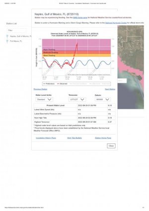
Naples has the highest water reported right now, about a 6 ft surge. It looked like it was going down a few minutes ago, but now it has ticked up again! Need to keep an eye on it. Water is lower in Ft Meyers, but rising fast. Naples water levels:Naples

Thank you. I have been keeping up with their weather.The towns at greatest risk are Naples, Venice, Cape Coral, Ft Meyers, and maybe Sarasota and Bradenton. Those are the bigger places, lots of small towns in-between. Those are on the coast on the bad side of the storm. The places were significant devastation is possible. Effects will be felt, awful weather and power outages over a much larger area. Also heavy rains can cause flooding over a much large area.
Not sure where @Pappy is, hopefully safe.
Naples has the highest water reported right now, about a 6 ft surge. It looked like it was going down a few minutes ago, but now it has ticked up again! Need to keep an eye on it. Water is lower in Ft Meyers, but rising fast. Naples water levels:
View attachment 241865
I think a lot of us are.I have been keeping up with their weather.
For sure.I think a lot of us are.
I know. A 6 foot or more surge. So sad for all these folks.Looking at flooding in Ft. Meyers now...... oh my gosh, it's awful! Parked cars are starting to float.
there you are ?.. are you safe ? I just posted your map of where you are to ask people if they knew if that area was safeI know. A 6 foot or more surge. So sad for all these folks.
He is on the east coast of FL. The storm has come ashore on the west coast and to the southwest of where he indicates. There are no good estimates on path expected other than toward Orlando but will travel cross the peninsula . Google 'spaghetti models' for best guesses of path it will take. All guesses. Mother Nature does as she pleases, will not follow suggestions.So Pappy posted a Map of where he is... anyone know if that area has got it bad..? what about you @jujube ?

@Pappy is near the Atlantic Ocean coast. The hurricane primarily is on the Gulf of Mexico side.there you are ?.. are you safe ? I just posted your map of where you are to ask people if they knew if that area was safe
