hollydolly
SF VIP
- Location
- London England
Thanks PB... but he just posted ahead of you, so we know he and Mrs P are safe@Pappy is near the Atlantic Ocean coast. The hurricane primarily is on the Gulf of Mexico side.
Thanks PB... but he just posted ahead of you, so we know he and Mrs P are safe@Pappy is near the Atlantic Ocean coast. The hurricane primarily is on the Gulf of Mexico side.
We haven't had the full effect yet. It probably won't still be at hurricane status when it goes by and the path moved a bit so it won't be coming over directly anyway.So Pappy posted a Map of where he is... anyone know if that area has got it bad..? what about you @jujube ?

Holly. No surge here. Tonight high winds and a lot of rain. Oh, and tornadoes warning. Thanks for asking.there you are ?.. are you safe ? I just posted your map of where you are to ask people if they knew if that area was safe
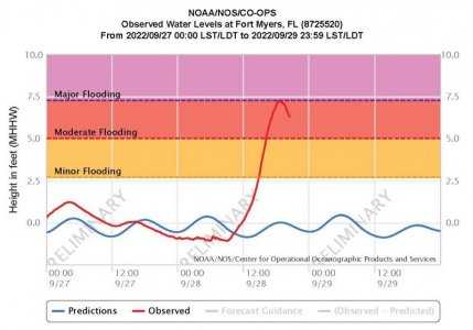
The surge could be higher on the barrier islands, no data from there. The median surge not so much as wave driven run up. Those barrier islands were however badly damaged in Charley in 2004, so the houses and buildings today should be more storm proof. Florida laws requires it.Ft Meyers away from the beach is flooding bad


I saw that video. I think it was just the roof floating down the street... not the entire house.fort Meyers away from the beach is flooding bad. Just saw a picture of a house and the only thing showing was the roof. Plus, usually, the highest winds are recorded when the north side of the hurricane first makes land.
Well, cape coral had 135 mph gusts when the storm hit, and now, on the south side, it hit a 140 mph gust. Unheard of.
I heard that during Hurricane Isabel Hatteras Village on Hatteras Island had a forty foot wall of water go across it from the ocean to the sound. It cut a swath out of Highway 12 leaving the village cut off for a few months. Roof tops, trailers, boats and other debris were floating in Pamlico Sound. During those months Supplies had to be airlifted and or brought in by boat. The school children were ferried to and from school by locals with boats. The highest wind speed recorded was 120 Mph. The forty foot surge came in before the eye wall hit the Island. Like I mentioned the highest wind speed was clocked at 120 Mph. They are saying Ian has winds up to 150 Mph. If one shelters in place there is no way out so you are stuck until the government opens the area back up and allow returns. In Hatteras it was a few weeks. No one in no one out. It was heart warming to see how the locals took care of each other.I think some of it is [over-hyped] ? It seems too me that in the case of several of the most recent storms I have heard ' a storm like we haven't seen in our lifetime' Storm surge of near twenty feet expected , usually turns out to be 12-18" Don't take me wrong, I want the lesser effects, but knock off the hype .
I don't know .... maybe I'm just all wrong ? Regardless , best wishes to all in the area effected ....... Stay safe !!
It is true that Isabel cut through Hatteras Island. However the storm surge was less than 40 feet, 6 to 8 feet at most. It is possible the large hurricane waves on top of that surge were higher. A 25 foot wave on top of an 8 foot surge could look 40 feet high. Certainly it was powerful enough to do lots of damage.I heard that during Hurricane Isabel Hatteras Village on Hatteras Island had a forty foot wall of water go across it from the ocean to the sound. It cut a swath out of Highway 12 leaving the village cut off for a few months.
When I lived in Florida I saw some of the camera crews filming "devastation". They were really good at making things look a lot worse than they were. Near us there were several houses that were eroding into the Gulf, they had been abandoned and looked really bad, on a good day. When a storm struck you could count on the news crews filming those places, making it look like real damage...I saw that video. I think it was just the roof floating down the street... not the entire house.
Naples, Cape Coral, Fort Myers, Punta Gorda and Port Charlotte are a few cities that come to mind. They were devastated by Hurricane Charlie 18 years ago, so hopefully they have fortified and become more aware (for the older residents) this time around.it syas it's currently pummeling the SW of Florida.. for the unitiated can you or someone tell us what towns or cities are in SW Florida.. is Pappy there ?
I didn't realize it was heading your way until I read your post yesterday. Then I saw it on the news today. Since the track and forecast keeps changing, I sincerely hope it will bypass you or have minimal impact if it doesn't. Either way, you know I'll be keeping you and Mrs. Pecos in prayer MDB!The latest forecasts for our area has Ian coming right over us on Sat at 2 in the afternoon. Who knows what the wind speed will be after it crosses the State of Georgia, but I have some work to do outside to get ready for it.
I have been through a couple of Hurricanes/Typhoons and seen what they can do. They are not to be trifled with. On Okinawa, I was always the guy who had to stay in the Operations building when they hit.
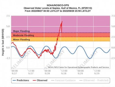
I am sure there is some flooding, the surge peaked at about 6 feet, well above flood stage. Most of the town probably isn't underwater, but some of it has flooded for sure. Do you know how close your friend is to the water, or at what elevation? If low and close to the water they may be flooded. Hope not!As I was trying to find the latest news about the Naples area, I heard a news blip that said the town my BFF lives in was "underwater" according to a town official. I sincerely hope that's an exaggeration, though I suspect it's quite bad.
When I visited her, it seemed like we only walked a couple of blocks to get to the beach, maybe 3-1/2 blocks. But that's over 30 years ago so I don't remember for sure. Elevation is reported to be 13 feet. Thank you Rob.I am sure there is some flooding, the surge peaked at about 6 feet, well above flood stage. Most of the town probably isn't underwater, but some of it has flooded for sure. Do you know how close your friend is to the water, or at what elevation? If low and close to the water they may be flooded. Hope not!
