View attachment 396414
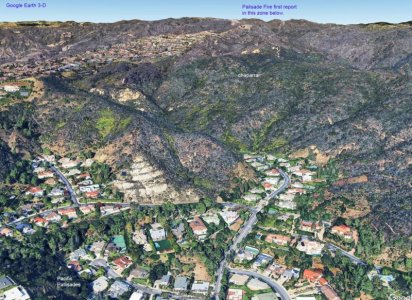
Although that controlled burn strategy might work in some landscapes with some vegetation types, that is not the case in the City of Los Angeles
Santa Monica Mountains.
The reason they probably never did that was because with greater brainstorming and consideration, they realized simply burning small sections at a time of the urban chamise-chaparral interface at the base of the canyons with intervening ribs and the highly erodable sandstone, siltstone, mudstone geology they found thereabouts, wasn't practical long term and short term would result in likely severe erosion if those deep brush plant roots were removed. Such erodable former marine sedimentary geologies are common throughout California coastal ranges with chamise-chaparral one of the only brush species well adapted to it.
CalTopo - Backcountry Mapping Evolved
All those slopes have burned at times over the last century. One can view at least recent decades fire by selecting the
Caltopo dot com
Map Overlays, Fire History option. It is only within the recent few decades people have built roads and homes into those areas. Some areas are already severely eroded. If they were going to remove chaparral, it would need to be able to cover the significant acreage. There are no other species with robust enough roots able to grow into those soils, they might replace the brush with. What they found does grow are grasses with short weak roots that won't help limit erosion. Planting grasses atop slopes has value with lower gradient slope where cattle might graze but not these steeper canyon forming slopes.
In any case, any such chaparral brush areas so burnt would within a few years be just as physically large above ground as they were before being burned because the roots don't die but rather root sprout given winter rains. Thus would need to have those areas reburned periodically every decade plus as the oily flammable plants grow back quickly in just a few years.
There are mountainous places in our coast ranges where brushes are absent and ground is bare, they are called "badlands" and can be found in limited zones throughout the West. They may have severe weird erosion formations. In California I've explore some of those nearly barren of vegetation places extensively during wildflower springs for example in the Temblor Range of Carrizo Plain National Monument, Anza Borrego State Park, and in Death Valley National Park. Difficult places to climb about through without trails with many steep, landslide prone, loose slopes.
As I related earlier, IMO the only logical strategy building in such high fire hazard chaparral areas is to do so with non-combustables material while accepting high Santa Ana wind with aerial ember fire storms will happen periodically regardless of whatever puny mitigation humans might try, they will need to be able to survive. To not do so, is to accept losses a builder or owner must individually swallow losses for. Unfortunately most of these areas have already been densely built into with ultra expensive homes that were not built to survive such fire events during an era architecture wasn't concerned with fire issues.
Instead, an imagined LIE the real estate industry must love, has apparently forever floated loosely in minds of residents, that fire departments and city planning must have figured protection out.
As how else, would all this world class valuable infrastructure have been allowed to have been built over decades if such were not so. Lots of smart people don't seem worried. So why ought I? Each year it never burned only encouraged more of the same, a fool's gamble, sober experts have warned against for decades.


