2024 - How's the Weather Where You Are?

Status
Not open for further replies.
13 JUNE 2024 4 PM EDT
THE NATIONAL WEATHER SERVICE HAS ISSUED SEVERE THUNDERSTORM WATCH
408 IN EFFECT UNTIL 9 PM EDT THIS EVENING FOR THE FOLLOWING AREAS

IN MICHIGAN THIS WATCH INCLUDES 14 COUNTIES:
IN CENTRAL MICHIGAN

GRATIOT MONTCALM
IN SOUTH CENTRAL MICHIGAN
CALHOUN CLINTON EATON
INGHAM IONIA JACKSON
IN SOUTHWEST MICHIGAN
ALLEGAN BARRY KALAMAZOO
KENT OTTAWA VAN BUREN
THIS INCLUDES THE CITIES OF ALLEGAN, ALLENDALE, ALMA, BANFIELD, BATH, BATTLE CREEK, BELDING, BRADLEY, BROOKFIELD, CHARLOTTE, COVERT, DEWITT, DORR, DOWLING, EAST LANSING, EASTMANVILLE,
EATON RAPIDS, ELM HALL, FENNVILLE, FOREST HILL, GOWEN, GRAND LEDGE, GRAND RAPIDS, GRAND VALLEY, GREENVILLE, GRESHAM, HARTFORD, HASTINGS, HOLLAND, IONIA, IRVING, ITHACA, JACKSON,
JENISON, KALAMAZOO, KEELER, LAMONT, LANGSTON, LANSING, MARNE, MATTAWAN, MCDONALD, MIDDLEVILLE, ORLEANS, OTSEGO, PAW PAW, PLAINWELL, PORTAGE, PORTLAND, RIVERDALE, SMYRNA, SOUTH HAVEN, ST. JOHNS, ST. LOUIS, TURK LAKE, WACOUSTA, WAVERLY, WAYLAND, WOODBURY, AND WYOMING.
 

Beautiful day here today. They had predicted showers but it's been full sun and around 24-25C Think that's around mid-70's F?
Just a perfect summer day (even though it's still spring I guess).
 
I went for a drive with the roof open and the windows down. Mostly 55 MPH on back roads, many stretches treed-over and shady. I don't burn fuel for the halibut often, but it was a nice ride, I averaged 44 MPG, and I could crank my tunes up without annoying anyone.
 
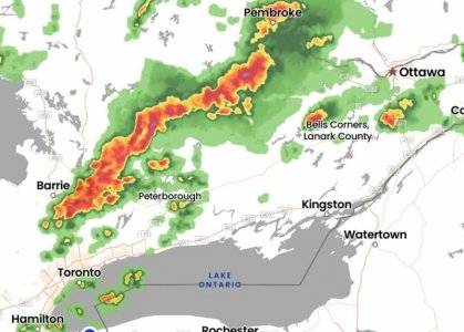
Severe thunderstorms rolling across southern Ontario this evening. The federal emergency warning system has gone off on TV a few times warning of possible toronados north of Toronto all the way over to Eastern Ontario near Ottawa.
View attachment 351167
Praying this won't set off any fires.🙏
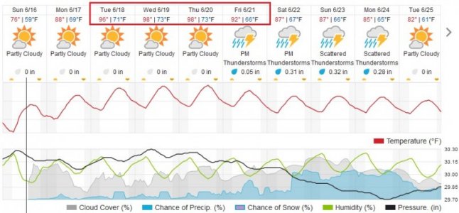
We're in for a heat wave this coming week .. I don't mind the heat so much. Humidity is what makes a big difference.
I Hate heat waves, especially the humidity, I can deal with dry heat up to a point but hate humidity.
 
Excessive Heat Watch: Source: U.S. National Weather Service

START 12:00 PM Monday, June 17 - END 8:00 PM Friday, June 21

...EXCESSIVE HEAT WATCH IN EFFECT FROM MONDAY AFTERNOON THROUGH FRIDAY EVENING...
* WHAT...Dangerously hot conditions with heat index values up to 100° F possible.
* WHERE...Portions of central, south central, southwest, and west central Michigan.
* WHEN...From Monday afternoon through Friday evening.
* IMPACTS...Heat related illnesses increase significantly during extreme heat and high humidity events.
* ADDITIONAL DETAILS...Heat index values near 100 degrees will have a cumulative affect through the course of the week. Temperatures at night will only fall into the 70s. So, the affect of the heat will build through the course of the week.
PRECAUTIONARY/PREPAREDNESS ACTIONS...
Drink plenty of fluids, stay in an air-conditioned room, stay out of the sun, and check up on relatives and neighbors.
 
Storming all night and for the last 2 hours I keep thinking "it's over in a bit" based on doppler radar imagery. But nope. New waves keep birthing out of nothing as earlier ones move on.

Just had a big bright orange flash and CRACK-KABOOM within half a second out my window. Too fast to even pull my hands back off the keyboard. No new sirens, so maybe nothing's caught fire from that one?
 
...FLOOD ADVISORY IN EFFECT UNTIL 115 PM EDT THIS AFTERNOON...
* WHAT...Flooding caused by excessive rainfall is expected.
* WHERE...A portion of south central Michigan, including the following counties, Clinton and Ingham.
* WHEN...Until 115 PM EDT Monday.
* IMPACTS...Minor flooding in low-lying and poor drainage areas.
* ADDITIONAL DETAILS... - At 522 AM EDT, Radar and automated rain gauges indicated heavy rain. Minor flooding is ongoing or expected to begin shortly in the advisory area. - Automated gauges in the area show 2 to 4 inches of rain has fallen. Additional rain is expected through 800 am EDT. - Some locations that will experience flooding include... Lansing, East Lansing, Capital Region International Airport, Edgemont Park, DeWitt, Okemos, Bath, Haslett and Holt. - Flood Safety Tips and Resources

PRECAUTIONARY/PREPAREDNESS ACTIONS...
Turn around, don't drown when encountering flooded roads. Most flood deaths occur in vehicles.
Wow. That sounds iffy at best. I hope it settles down soon. I knew that Florida, especially southern Florida is getting hammered. There is so much moisture in the air it's crazy. Here it will be 90F again. We will have about 10 days of this, ALREADY. I turned on my air conditioner in my room 2 days ago, at least two weeks earlier than last year.
 
Wow. That sounds iffy at best. I hope it settles down soon. I knew that Florida, especially southern Florida is getting hammered. There is so much moisture in the air it's crazy. Here it will be 90F again. We will have about 10 days of this, ALREADY. I turned on my air conditioner in my room 2 days ago, at least two weeks earlier than last year.
We're looking at 93 F here today. We'll see.
 

Status
Not open for further replies.

Back
Top